

Combining spectral, thermal and radiometric measurements for more informed crop and water management
| APPLICATION Crop health, irrigation and stress assessment |
IMAGING Visible, red-edge, NIR, SWIR and thermal |
MEASUREMENT Calibrated, georeferenced and time-synchronized data |
The Challenge
Crop and irrigation decisions are influenced by several interacting factors: vegetation condition, leaf and soil moisture, canopy temperature, sunlight and local atmospheric conditions. A conventional visual map or a single sensor can reveal useful patterns, but may not explain why a particular area appears stressed. Illumination changes, exposed soil and atmospheric variability can also complicate comparisons between fields or survey dates.
The Integrated Imaging Approach
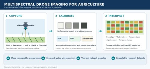
The proposed approach combines drone-based visible, red-edge, near-infrared (NIR), short-wave infrared (SWIR) and long-wave infrared (LWIR) imaging. Each spectral region contributes different information: visible images document crop structure and visible symptoms; red-edge and NIR measurements help characterize vegetation condition and vigor; SWIR provides sensitivity to water absorption; and thermal imaging measures canopy and surface temperature.
The concept goes beyond collecting images. A solar-irradiance sensor, ground reflectance target, GPS, time synchronization and environmental/positional metadata help account for illumination and location differences. Radiometric calibration is intended to convert raw imagery into absolute reflectance and temperature values that can be compared across flights and used in scientific analysis and modelling.
Illustrated Workflow
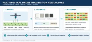
Conceptual illustration created for this case study; it is not a real flight dataset or validated crop-stress map.
Applications
Why Combine Multiple Spectral Bands?
Thermal or radiometric measurements used alone can be ambiguous because soil background, changing sunlight and atmospheric conditions affect the observed signal. Combining visible, red-edge, NIR, SWIR and thermal data with calibration infrastructure adds context to interpretation. The objective is to reduce false positives and improve the reliability of decisions—not simply to produce more images or relative vegetation indices.
Expected Benefits
Implementation Considerations
The source proposal describes an integrated sensor payload and supporting calibration architecture; it does not report field-trial results, quantified accuracy, yield improvement, water savings or a validated crop-classification model. These outcomes should not be assumed. Practical deployment would require calibration procedures, appropriate flight planning, sensor co-registration, ground-truth observations and validation against the target crops, soils and environmental conditions.
Source and Acknowledgement
This case study is based on the supplied document, “Integrated Multispectral & Radiometric Drone Payload for Agricultural and Atmospheric Research,” prepared by Online Solutions, Chennai, for proposal understanding. The write-up describes a proposed system concept and its intended use cases; it is not presented as a completed field deployment or a validated performance study.
Disclaimer
This document is for general informational and application-discussion purposes only. The described workflow and illustration are conceptual. No claims are made regarding measured field performance, diagnostic accuracy, yield gains, water savings or commercial readiness. Agricultural decisions should be based on suitable calibration, local agronomic expertise, ground observations and validation for the crop and environment concerned. The illustrative image is not actual sensor output.
We'll be glad to help you! Please contact our Sales Team for more information.
We'll be glad to help you! Please contact our Sales Team for more information.