

How rugged industrial camera technology supports image-based navigation beyond Earth
| APPLICATION Spacecraft optical navigation and image capture |
CAMERA PLATFORM Pixelink 5 MP CMOS industrial camera |
MISSION CONTEXT Earth/Moon imaging during launch and re-entry |
The Challenge
A crewed spacecraft operating beyond low Earth orbit must be able to determine its position and trajectory even when communication with Earth or ground-based navigation support is unavailable. For NASA’s Orion Multi-Purpose Crew Vehicle (MPCV), optical navigation uses images of celestial bodies—including Earth and the Moon—as inputs to the spacecraft’s navigation process. Camera hardware for this role must meet demanding performance requirements and remain functional in the severe environmental conditions associated with spaceflight.
The Imaging Solution
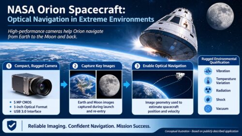
According to Navitar’s published case study, NASA selected Pixelink industrial camera technology for the Orion Optical Navigation System. The navigation camera system is positioned in three locations on the spacecraft and captures images of Earth and the Moon during launch and re-entry. These images support the spacecraft’s ability to calculate its position and velocity in cislunar space, including circumstances where communication or ground-based navigation is lost.
Navitar identifies the camera configuration as a 5-megapixel CMOS camera with a 1-inch optical format and USB 3.0 interface. Ruggedized packaging and housing were used to address the harsh conditions of spaceflight. The cameras were tested against vibration, temperature variations, radiation, shock and vacuum pressure.
How Image-Based Navigation Supports the Mission
Illustration of the Camera-to-Navigation Workflow
Conceptual illustration prepared for this case study. It is not an official NASA or Navitar image, and does not depict the exact flight hardware installation.
Operational Significance
The Orion example demonstrates how industrial imaging technology can be adapted for a mission-critical space application. Robust camera packaging, image capture capability and qualification for demanding environmental conditions are important when camera data contributes to navigation decisions. In this case, optical imaging is part of a broader navigation system; the camera alone does not calculate the spacecraft trajectory.
Technology Details at a Glance
| Camera technology | Pixelink industrial camera |
| Sensor | 5 MP CMOS |
| Optical format | 1 inch |
| Interface | USB 3.0 |
| Reported placement | Three locations on the Orion spacecraft |
| Imaging targets | Earth and Moon |
| Environmental tests stated by Navitar | Vibration, temperature variations, radiation, shock and vacuum pressure |
Source and Acknowledgement
This case study is based primarily on Navitar’s published “NASA Orion Spacecraft Project” case study. Navitar credits Pixelink camera technology as the imaging platform selected for the Orion Optical Navigation System. Additional context on Orion’s optical navigation role is drawn from NASA’s public avionics and software reference. Product details and statements about the camera selection and tests are attributed to Navitar; NASA remains the source for mission-system context.
Navitar case study: https://www.navitar.com/capabilities/casestudies/nasa-orion-spacecraft-project
NASA avionics and software reference: https://www.nasa.gov/reference/avionics-and-software/
Disclaimer
This document is an informational case study prepared from publicly available material. It is not an official NASA or Navitar publication and has not been reviewed or endorsed by either organization. The illustration is conceptual and is not a photograph of flight hardware or an exact system diagram. The camera specifications, selection and environmental test statements are summarized from Navitar’s case study; no additional performance figures or independent test results are implied. Spacecraft navigation depends on a complete, validated system of sensors, algorithms, software and mission procedures, not on the camera alone. Confirm current technical specifications and usage permissions with the relevant rights holders before commercial publication.
We'll be glad to help you! Please contact our Sales Team for more information.
We'll be glad to help you! Please contact our Sales Team for more information.