
As History tells us, On December 17, 1903, Wright brothers (Wilbur and Orville) succeeded in flying the first free, controlled flight of a power-driven, heavier-than-air plane. Wilbur flew their plane for 59 seconds, over a distance of 852 feet, an extraordinary achievement.
From then on, the flying industry or in proper words aviation industry started and grew to an extent that millions travel, tons of goods shipped, aid provided, wars fought using the modern aeronautics and flights made of those techniques.
All these aircrafts are man driven and then came the era of unmanned aircraft or aircraft vehicle controlled remotely. Most of these unmanned aircraft were put for military monitoring purposes. As we see, all the large equipment from huge room size computers to palm size devices (more powerful than huge ones), this industry also started seeing changes to make lesser size, more efficient unmanned aircraft and these were termed as drones.
The term drone has been used from the early days of aviation, being applied to remotely flown target aircraft used for practice firing of a battleship’s guns.
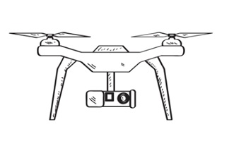
In simple, A drone is an unmanned aircraft. Drones are more formally known as unmanned aerial vehicles (UAVs) or unmanned aircraft systems. That is a machine that can fly without a human pilot. Its flight path is programmed by software or controlled by remote control.

Drones are classified into types based on wing types (Multi Rotor, Single Rotor, Fixed Wings etc.…), size (medium, small etc..), payload capacity (Light weight, Middle weight, Heavy lift etc..), range or flying distance (Close range, Short Range, Mid Range etc..), power sources, abilities and purpose, motors used etc.
Not all drones have a camera system, but models offer additional options in-flight, such as aerial photography, cinematic photography, or pilot’s eye view (FPV) flight. As with drones, video systems are available in various models and layouts when considering drone uses and have their parts, such as the gimbal, video transmitter, antenna, storage, processing units etc.
Drones can have various cameras due to their versatility and adaptability to different tasks and environments. Depending on the application, drones may require different types of cameras to capture visual data, including RGB cameras, thermal cameras, multispectral cameras, zoom cameras, and 360-degree cameras.
For instance, drones used in agriculture may use multispectral cameras to monitor crop health and detect areas of stress or disease, while drones used in search and rescue missions may use thermal cameras to detect heat signatures of people or animals in distress. Similarly, drones used in the entertainment industry may use 360-degree cameras to capture immersive panoramic footage, while drones used in surveillance applications may use low-light cameras to capture clear images in low-light conditions. The versatility of drones allows them to be customized to specific applications and equipped with the most suitable cameras to capture the necessary data.
Off late, with Machine Vision cameras available in smaller sizes and weights and providing high resolution with no compression, these cameras are preferred to be used in Drones. Still, the SBC s or embedded systems to be used with these cameras that come with Vision protocols are to be managed effectively. Most of these high-resolution cameras can be used only with lower frame rates due to interface bottlenecks with SBC s and embedded boards. Most of these machine vision cameras do not have any permanent storage to store images or video and hence the storage on board is also needed with those embedded systems. Most challenging is to work on colors ( as these cameras come with BAYER interpolation) and focusing. As these high-resolution cameras when operated in very low frame rates like one or two frames per second, visually watching and fixing a lens focus is not easy though one could keep the aperture open all the time as standard procedure. Auto Focus or Motor driven focus lenses are many a time bulky and may not fit the payload capacity of the drones. This means a lot of work on software filtering and focus correction without damaging the original images need to be done depending up on the need.
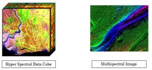
Multispectral, Hyperspectral and NIR cameras are very important cameras for drones when they are used for agriculture, mining, Military and other related purposes. Multispectral as its name suggests captures different spectrums of light say RGB and Mono or RGB and NIR etc… The human eye sees color of visible light in mostly three bands (long wavelengths – perceived as red, medium wavelengths – perceived as green, and short wavelengths – perceived as blue), spectral imaging divides the spectrum into many more bands. This technique of dividing images into bands can be extended beyond the visible. In hyperspectral imaging, the recorded spectra have fine wavelength resolution and cover a wide range of wavelengths. Hyperspectral imaging measures continuous spectral bands, as opposed to multiband imaging which measures spaced spectral bands. Hyperspectral imaging collects many individual images of a scene, each taken within a different narrow wavelength band. The result is a “data cube” of the combined images. These data cubes have to be handled by the designated software to understand more.
There are camera companies that make these hyperspectral imaging with filters applied on sensors or interference chip level filtering etc… These cameras would also require a compatible lens system to allow all the spectrum of light in need inside
In all cases, usage of high-resolution cameras or these spectral cameras would need proper Single Board Computers or embedded systems with Storage to capture and store the images for ground station processing. In many cases, you do not need to see or you cannot see live videos. Images are to be stored and powerful ground station systems are required to process these images. Deep Learning and other artificial intelligence techniques can also be used for continuous processing and interpretation of needed info from the captured images.
With Drones and the need for drones for all kinds of services growing across the globe, Imaging with drones would keep improvising day by day.
We Online Solutions (Imaging) Pvt. Ltd., Chennai India can provide machine vision camera solutions for high resolution image capture, support for integration with SBC s and Embedded system ( restricted), optics suggestions and also Multi and Hyper spectral camera solutions. We represent different companies from across the globe like Teledyne DALSA for their camera solutions in India. We had worked with India’s first unmanned aircraft’s camera, optics and ground station processing.
Drone – in its true English meaning means a deep sustained or monotonous sound. But Drones of this era are making more sound in terms of TECHNOLOGY NEED especially in Imaging.
Disclaimer: The above article is only for informative purposes. The contents are self-written or taken from different sites available. If anyone finds the content or usage objectionable then they can mail us at [email protected] to do corrective measures. . The contents can be rechecked for their correctness by the readers.
Article created by: S Sukumar – Director Online Solutions (Imaging) Pvt. Ltd., Chennai India on 28 December 2023.
We'll be glad to help you! Please contact our Sales Team for more information.
We'll be glad to help you! Please contact our Sales Team for more information.